


Blog > What a Flood Zone Designation Actually Means for Your Mississippi Gulf Coast Home
What a Flood Zone Designation Actually Means for Your Mississippi Gulf Coast Home
by
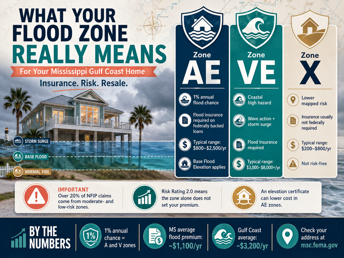
Flood Zones on the Mississippi Gulf Coast: What the Letters Mean
Quick Answer: Your flood zone designation comes from FEMA's flood maps and tells you two things: how likely your property is to flood, and whether flood insurance is required on a mortgage. Zones starting with A or V carry a 1% annual flood chance and require insurance on a federally backed loan. Zone X sits outside that mapped high-risk area, but it isn't a guarantee of safety, since over 20% of NFIP claims nationally come from moderate- and low-risk zones. Premiums on the coast now run from around $800 a year in lower-risk zones to $8,000 or more in Zone VE.
What Do the Letters in Your Flood Zone Actually Mean?
Each letter tells you something specific about your flood risk. Zone AE means FEMA has done a detailed study and established a Base Flood Elevation, the height floodwater is expected to reach in a serious flood. It's the most common high-risk zone on the coast and the one where insurance requirements hit hardest.
Zone VE is the coastal high hazard zone, meaning your property faces wave action and storm surge on top of flooding, and it's common along the Mississippi coast from Bay St. Louis to Pascagoula. Zone X sits outside FEMA's mapped 1% annual chance floodplain, either in the lower-risk 0.2% band or fully outside any mapped hazard. You'll see new construction advertised in Zone X in places like north Waveland for exactly that reason.
You can look up any address for free at FEMA's Flood Map Service Center, msc.fema.gov, and see the zone, the map panel, and the Base Flood Elevation if one applies.
Does Your Flood Zone Determine Whether You Must Carry Flood Insurance?
Yes, if you have a federally backed mortgage. Any property in a Special Flood Hazard Area, which covers all the A and V zone variants, requires flood insurance by law if the loan is conventional, FHA, VA, or USDA. Zone X doesn't carry that federal requirement, but your lender can still require it based on their own risk review, and plenty do on the coast.
If you're paying cash, there's no legal requirement anywhere, though skipping coverage on a coastal property is a real gamble. Listings sometimes just note "subject to survey" instead of stating the zone outright, so it's worth confirming directly with the FEMA map rather than assuming from the listing description.
One thing flood insurance is not: wind coverage. Storm surge and rising water are flood. Wind damage is a separate peril on a separate part of your policy stack, and flood is always its own policy on this coast.
How Much Does Flood Insurance Actually Cost for Your Zone?
It varies a lot, and the zone alone doesn't set the price anymore. Under FEMA's Risk Rating 2.0, which began phasing in during October 2021, policies are priced using the individual property rather than just the zone, factoring in distance to water, elevation, foundation type, construction, and claims history.
That said, the zone still shapes the range. Zone AE properties typically run $800 to $2,500 a year, Zone VE can reach $3,000 to $8,000 or more, and lower-risk Zone X coverage often falls between $200 and $800 a year through NFIP's Preferred Risk Policy. Mississippi's statewide average sits around $1,100 a year, but Gulf Coast properties specifically average closer to $3,200, which tells you how much the coast skews the state number.
Can an Elevation Certificate Lower What You Pay?
Often, yes, especially in Zone AE. An elevation certificate documents how high your home's lowest floor sits relative to the Base Flood Elevation. As a general rule, being a foot or two above that line prices better, and the difference can be substantial. Under Risk Rating 2.0 the exact savings depend on your specific property, so nobody can quote you a percentage before they run your address. What's true is that you submit a certificate only if it helps you, which makes it a one-way option worth having.
It's a document a licensed surveyor prepares, and it's worth having in hand whether you're insuring your current home or getting ready to sell. Buyers and their lenders increasingly ask for one up front, since it speeds up their own insurance quote. If you don't have one and your home sits in a mapped flood zone, it's a reasonable investment before you list or before your next renewal.
Does Being Outside a Flood Zone Mean You're Actually Safe?
Not entirely, and this is where a lot of homeowners get caught off guard. More than 20% of NFIP claims nationally come from moderate- and low-risk zones, including Zone X.
After Hurricane Katrina, more than 112,000 owner-occupied homes across Louisiana and Mississippi that flooded were sitting outside the official flood zones at the time. Maps also get updated periodically as FEMA completes new studies, so a property's zone can change even if nothing about the home itself has.
Being in Zone X is genuinely good news for your insurance bill, but it isn't a promise that water can't reach your home in the right storm.
By the Numbers
Special Flood Hazard Area (A and V zone variants): 1% annual chance of flooding
Zone AE annual flood insurance cost range: $800 to $2,500
Zone VE annual flood insurance cost range: $3,000 to $8,000 or more
Zone X Preferred Risk Policy cost range: $200 to $800 a year
Mississippi statewide average flood premium: about $1,100 a year
Gulf Coast-specific average flood premium: about $3,200 a year
Share of NFIP claims from moderate- and low-risk zones nationally: over 20%
Owner-occupied homes flooded outside mapped zones in Louisiana and Mississippi during Katrina: more than 112,000
Risk Rating 2.0 phase-in began: October 2021
The Bottom Line
Your flood zone letter isn't just paperwork, it drives whether you're required to carry insurance and roughly what you'll pay for it. But the letter alone doesn't tell the whole story anymore, since individual property details now shape your actual premium, and a "safe" zone designation still isn't a guarantee. Pull your own address on FEMA's map, get an elevation certificate if you're in a mapped zone, and don't assume Zone X means you're in the clear. If you're shopping, get the quote before you write the offer, and our buyer's guide covers the rest of the Coast-specific steps.
Frequently Asked Questions
How do I find out my property's flood zone?
Go to FEMA's Flood Map Service Center at msc.fema.gov and enter the address. It shows your current zone, the map panel, and the Base Flood Elevation if one has been established for your area.
Is flood insurance required in Zone AE?
Yes, if you have a federally backed mortgage such as FHA, VA, conventional, or USDA financing, flood insurance is legally required on any property in Zone AE or another Special Flood Hazard Area designation.
Why did my flood insurance go up even though my zone didn't change?
FEMA's Risk Rating 2.0 system now prices policies based on individual property factors like elevation, distance to water, and construction type, not just the flood zone, so your premium can shift even without a zone change.
Does an elevation certificate really make a difference in cost?
In Zone AE especially, it can. Sitting above the Base Flood Elevation prices better, though under Risk Rating 2.0 the exact savings depend on your specific property. You submit the certificate only if it helps, so it's worth finding out whether you already have one.
If I'm in Zone X, do I still need flood insurance?
It's not federally required unless your lender specifically asks for it, but over 20% of NFIP claims nationally come from Zone X and similar lower-risk areas, so voluntary coverage is still worth considering on the coast.
Can a named storm delay my flood policy?
Flood works differently than wind. NFIP policies carry a 30-day waiting period, but coverage tied to a loan closing takes effect at closing with no wait, as long as the application and premium are presented on time. Wind is the one that freezes when a named storm enters the Gulf.
Sources
FEMA Flood Map Service Center — flood zone lookup, map panels, and Base Flood Elevations
FEMA National Flood Insurance Program — Special Flood Hazard Area definitions and mandatory purchase requirement
Randy Richardson | Broker Associate
The 4th Right Team | Century 21 J. Carter & Company
📞 Office: (228) 731-3881 | Cell: (228) 547-9999
📧 realtorrandyrichardson@gmail.com
🌐 www.The4thRightTeam.com
Looking to SELL or BUY? I know a GUY!