


Blog > The 4 Kinds of Waterfront on the Mississippi Gulf Coast
By Randy Richardson, Broker Associate, The 4th Right Team at Century 21 J. Carter & Company.
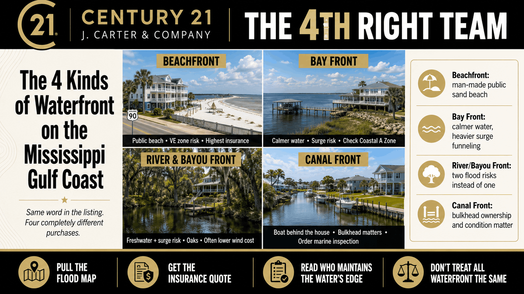
Quick Answer: There are four kinds of waterfront on the Mississippi Gulf Coast, and they aren't interchangeable. Beachfront on Highway 90 faces the Mississippi Sound, not the open Gulf, and the sand in front of you is a 26-mile man-made public beach the county has maintained since 1951. Bay front sits on protected water but takes the worst of storm surge. River and bayou front carries two separate flood risks instead of one. Canal front comes with a bulkhead that belongs to you and that no home inspector will check. Same word on the listing. Four completely different purchases.
Buyers moving here see "waterfront" in a listing and picture one thing. Around here it means four things, and the differences show up in your insurance bill, your building requirements and what you're responsible for maintaining.
What Are the Four Kinds of Waterfront on the Mississippi Gulf Coast?
Beachfront, bay front, river and bayou front, and canal front. Beachfront runs along Highway 90 through Pass Christian, Long Beach, Gulfport and Biloxi. Bay front wraps the Back Bay of Biloxi, Biloxi Bay and St. Louis Bay. River and bayou front sits along the Tchoutacabouffa, the Wolf, the Jourdan, Old Fort Bayou and Bernard Bayou. Canal front means dredged, bulkheaded waterways in planned subdivisions like Gulf Hills, Gulf Park Estates, Diamondhead and Bayou Vista.
They can all say "waterfront" in the MLS. They can all have a dock. They don't price the same, insure the same or behave the same in a storm.
Is Highway 90 Beachfront Actually on the Gulf?
Not exactly, and this surprises people. You're looking at the Mississippi Sound, which runs about 90 miles east to west with a maximum depth of only 20 feet. The open Gulf sits on the far side of the barrier islands. Ship Island is about 12 miles offshore. Horn, Petit Bois and Cat are out there with it, taking the first hit from wave energy before it reaches you.
Here's the other thing nobody tells you. That beach isn't yours. Harrison County's 26 miles of white sand is man-made, built in 1951 with federal money, and the county's contract required it be dedicated to perpetual public use. The seawall behind it dates to 1928. A beachfront home usually means you own a lot on the north side of a four-lane highway, across from a public beach the county maintains. You get the view. You don't get private sand.
This is also where the strictest building rules live. Much of this stretch falls in a FEMA VE zone, a coastal high hazard area where waves reach three feet or higher. VE means open pilings, no slab on grade, breakaway walls below the base flood elevation and mechanical systems raised above it. It's the most expensive place on the Coast to build and to insure.
What Makes Bay Front Different From Beachfront?
Calmer water, different risk. The bays don't get the wave energy the beach does. What they get instead is surge. Water pushed by a hurricane funnels into a narrowing bay and has nowhere to go but up and inland, so bay front can flood badly on a day the waves never looked dangerous.
A lot of bay front lands in an AE zone rather than VE, which usually means lower flood premiums and slab construction allowed above base flood elevation. Ask one more question before you relax. FEMA draws an informational line on newer flood maps called the LiMWA, the Limit of Moderate Wave Action. The strip of AE between that line and the VE boundary is the Coastal A Zone, and FEMA's own post-storm surveys show waves as small as a foot and a half do serious structural damage to buildings that weren't designed for them. An AE rating alone won't tell you whether you're in that strip. The map will.
What Should I Know Before Buying on a River or Bayou?
That you're carrying two flood risks, not one. Surge can push saltwater up the Tchoutacabouffa or the Wolf from the bay end. Rainfall can send freshwater down from the north at the same time. A storm that stalls over the watershed can flood a house surge would never have reached, and most buyers only think about the first one.
The upside is real. Most river and bayou frontage sits north of the beach, sometimes north of I-10, which usually means lower wind exposure and a cheaper wind policy than an equivalent house on the water in Biloxi. You get big oaks, protected water and a dock without VE zone construction costs. Check bank stability, whether the seller has been losing yard to erosion, and whether your boat can reach open water at low tide and under the bridges between you and the bay.
What's the Catch With Canal Front Homes?
The bulkhead. Canal subdivisions were dredged out of marsh and low ground, and the retaining wall holding your yard back from the water is usually a private responsibility, not the association's and not the county's. It's also not part of a standard home inspection. A failing bulkhead can be a five-figure repair, and most people find out after closing.
So do three things before you write. Read the plat, the deed and the POA documents to see in writing who owns and maintains the bulkhead and who's responsible for dredging the canal if it silts in. Pay for a separate marine or seawall inspection, which is a specialty inspection you have to request. And walk the neighbors' bulkheads, because canals fail in stretches, not one lot at a time.
The trade is often worth it. Canal front is usually the cheapest way to get a boat behind your house on this coast, and the water is protected. Just price the bulkhead before you price the house.
By the Numbers
Mississippi Sound maximum depth: 20 feet
Distance from the Mississippi coast to Ship Island: about 12 miles
Harrison County man-made sand beach: 26 miles, built 1951
Harrison County seawall completed: 1928
FEMA VE zone threshold: breaking waves of 3 feet or higher
FEMA LiMWA threshold: wave heights of 1.5 feet
Biloxi median sale price, June 2026: $279,748
Gulfport median sale price, June 2026: $216,382
The Bottom Line
Waterfront on the Mississippi Gulf Coast is four different products wearing the same label. Before you fall for a view, pull the flood map, get an insurance quote during your inspection period, and read the documents that say who maintains the water's edge. Any of the four can be a great buy. Skip that homework and you'll learn the difference the expensive way. If you're shopping the canal side, start with homes for sale in Diamondhead or Pass Christian Isle.
Frequently Asked Questions
Is Mississippi beachfront property on the Gulf of Mexico?
Not directly. Homes along Highway 90 face the Mississippi Sound, which is separated from the open Gulf by barrier islands. Ship Island sits about 12 miles offshore, and the Sound itself is only about 20 feet deep at its deepest.
Do you own the beach if you buy a beachfront home in Biloxi or Gulfport?
Usually not. The 26 miles of sand beach in Harrison County is man-made and was dedicated to perpetual public use under the county's 1951 agreement with the federal government. Beachfront owners typically own across Beach Boulevard from a public beach.
Is bay front safer than beachfront in a hurricane?
It's different, not automatically safer. Bays get less wave action but funnel storm surge, so flooding can be severe even when the water looked calm. Check whether the property sits in the Coastal A Zone before you assume the risk is lower.
Who is responsible for the bulkhead on a canal front home?
In most canal subdivisions the bulkhead is the property owner's responsibility, but it varies by neighborhood. Read the plat, deed and POA documents, and order a separate seawall or marine inspection, since a standard home inspection doesn't cover it.
Which kind of Gulf Coast waterfront is cheapest to insure?
Generally river and bayou front, because it sits farther from open water and often north of the heaviest wind exposure. Beachfront in a VE zone is typically the most expensive. Get an actual quote for the specific address rather than relying on the pattern.
Sources
FEMA — Features of Flood Insurance Rate Maps in Coastal Areas, VE and AE zone definitions
FEMA — Coastal A Zone and LiMWA fact sheet, 1.5-foot wave damage findings
United States v. Harrison County, 399 F.2d 485 — 1951 federal contract and perpetual public dedication of the sand beach
Harrison County Sand Beach Master Plan — 26-mile man-made beach, 1928 seawall, county maintenance responsibility
Mississippi Department of Marine Resources — Harrison County Sand Beach Authority, 26 miles of man-made beach
National Park Service, Gulf Islands National Seashore — Ship Island 12 miles offshore
Redfin — Biloxi median sale price, June 2026
Redfin — Gulfport median sale price, June 2026
Randy Richardson | Broker Associate
The 4th Right Team | Century 21 J. Carter & Company
Office: (228) 731-3881 | Cell: (228) 547-9999
realtorrandyrichardson@gmail.com
www.The4thRightTeam.com
Looking to SELL or BUY? I know a GUY!